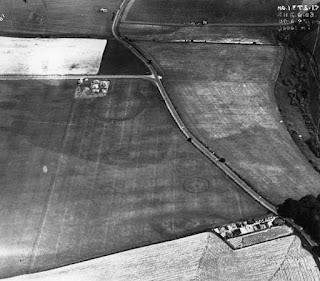
This is the aerial photograph that led to the discovery of Woodhenge.

This is the aerial photograph that led to the discovery of Woodhenge. In 1925, Squadron Leader Gilbert Insall was flying near the Wiltshire village of Durrington when he spotted strange formations in the wheat crop in a field below. Intrigued, Insall returned the following year and captured this bird’s eye view showing a distinctive pattern of dark spots, later revealed to be postholes. What his photograph had uncovered was the outline of a Neolithic timber monument. The site was excavated in 1926–7 by Maud and Ben Cunnington, who marked the positions of the wooden posts with concrete pillars for visitors. In 1929 a detailed site report was written by Maud Cunnington, who decided to name the site ‘Woodhenge’ because it had so many similarities to nearby Stonehenge. You can read Cunnington’s report here: https://bit.ly/3eaYr1O (courtesy of Antiquity Journal ) 📷: Historic England Archive We hope that you have enjoyed reading our blog on the "From Yesterday to Tomorrow: Exploring th...